10 things to do...
1. Start at the Visitor Center
The visitor center is open daily from 8 am to 6 pm during the summer
season, 8 am to 5 pm after Labor Day. Exhibits and video programs
interpret the cultural and natural history of the area. A booksales
area operated by the Natural History Association provides a variety
of educational materials, postcards, bump caps and posters. Rangers
are there to answer questions and provide information. Lanterns,
on loan, for exploring the caves are also available.
2. Explore a Lava Tube Cave
Caves can be explored on your own or with a ranger. For a safe
adventure you should have at least one light per person. Helmets
are highly recommended. Please do not eat or smoke in the caves.
The caves come in varying degrees of difficulty, ranging from
a lighted cave, Mushpot, in the center of the parking
lot, to the
mile-long Catacombs, with long stretches of duck walking or
crawling. Drop in at the Visitor Center. A ranger will be happy
to recommend
a cave or caves that would be just perfect for you, your family,
or friends. Don’t leave Lava Beds without trying one
of these gems.
3. Hike a Trail
Trails range in length from .75 miles to 9.5 miles one way. Be
sure to carry plenty of water and wear sun protection. A trail
brochure is available at the visitor center. Pets are not allowed
on the trails. The Bunchgrass Trail begins across from site B-7
in the campground. It follows an old roadbed around the northeast
side of Crescent Butte and is approximately 1 mile long. The
Three Sisters Trail also begins at the campground from Loop A.
This trail travels out into the back country and ends at Skull
Cave, about 8.75 miles distance.
Other trails include Big Painted Cave and Symbol Bridge which
begins on the Skull Cave road and winds .75 miles past lava tube
collapses to view pictographs at the bridge and cave. Heppe Cave
Trail, .75 miles, can be found on the road to Mammoth Crater. View
an enormous lava tube collapse and follow the trail down into Heppe
Cave which has a large opening at both ends.
Longer trails include the Whitney Butte Trail, 3.5 miles one way,
that begins at Merrill Cave and the Lyons Trail which connects
the Skull Cave parking lot with Hospital Rock, 9.5 miles one way.
4. Climb a Cinder Cone
Cinder cones are easily eroded so please stay on the established
trails and don’t take shortcuts. Frothy lava, cooled in
the air, created the large cinder cones throughout the monument.
Schonchin Butte’s .75 mile trail leads you to a panoramic
view from the historic fire lookout. The lookout is staffed from
June to September. Children of all ages can earn a Junior Fire
Lookout badge.
5. Visit a Battlefield Site
Battlefield sites include the Thomas-Wright battlefield, Gillems
Camp, Canbys Cross, Captain Jacks Stronghold, and Hospital Rock.
Explore these sites to learn the history of the Modoc war. Gillems
Camp, US Army Headquarters during the Modoc war, Canbys Cross,
where E.R.S. Canby was killed, and Hospital Rock can be visited
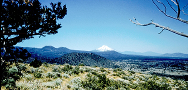
by a short walk from the parking lots. A walk to the top of Hospital
Rock leads you to an interpretive sign explaining the significance
of this area of the monument. It also affords you a beautiful
spot to view and photograph Mt. Shasta.
For a longer tour, hike the 1.2 mile trail from the Black Crater
parking lot to the site where Captain Evan Thomas and Lieutenant
Thomas Wright lost half their men. A self-guiding brochure is available
at the trailhead at Captain Jacks Stronghold. As you travel through
this lava fortress you will see how the Modocs held off a force
10 times their strength. Inner loop .6 miles, outer loop 1.1 miles.
Be prepared for rough terrain.
6. Discover
a Spatter Cone
Picnic tables and a wheelchair accessible toilet are available
at Fleener Chimneys. Fleener Chimneys and Black Crater are castle-like
formations created by globs of molten lava which piled up on
top of eachother. Varying textures and colors will delight photographers.
Fleener Chimneys has a picnic area shaded by western juniper
trees. The picnic tables were constructed by members of the CCC;
the logs were obtained at Oregon Caves NM and the rocks were
gathered locally.
7. View a Crater
Mammoth Crater and the nearby Modoc Crater is the source of lava
that created many of the caves in the monument. Drive to Mammoth
Crater and Hidden Valley on a dirt road just north of the visitor
center. Hidden Valley, across the road from Mammoth Crater is
a large conduit for the lava which flowed from the crater toward
Tule Lake about 30,000 years ago. Experience the solitude of
the ponderosa pine forest on a short trail that leads to the
bottom of the valley.
8. Examine an aa Flow
AA is a type of lava that is very sharp in texture. A good place
to view a lava flow is at the Devils Homestead. How is this lava
different from what you find in the caves?
9. Travel to the Past
One of the largest panels of petroglyphs in California can be found
at Petroglyph Point at the northeast corner of the monument.
Please treat this cliff with great respect and do not add your
drawings to the panel. Early people paddled out in boats to carve
these pictures into the soft rock, some may be more than 4,000
years old. Natural nesting sites for birds of prey such as barn
owls and prairie falcons have been eroded into the cliff by wind
and rain. A brochure is available at the site to explain a short
walk along the bottom of the cliff. A trail that leads to the
top begins from the road .3 miles beyond the parking lot.
10. Join a Ranger
Ranger-guided programs are conducted daily from Memorial Day to
Labor Day. No reservations are necessary. Walks and cave tours
meet at the visitor center porch. During the winter programs
are available with advance reservations. For more information,
contact the visitor center at 530/667-2282, ext 232.